
A hurricane at sea looks like a giant spinning storm. It’s essentially a huge circular swirl of clouds over the ocean, with a surprisingly clear, calm center (the eye) surrounded by towering walls of storm clouds. In NASA and NOAA images, the hurricane appears as a massive white spiral of clouds over the blue water – a “nearly perfect circular eye” at the center of the storm. NOAA explains that “a hurricane’s eye is its clear center, and the calmest part of the storm. The eye is surrounded by a wall of deep clouds and deadly winds”. In other words, from above it looks like a giant spiral or pinwheel, while at sea level you’d see dark, swirling skies, intense winds, and enormous waves all around.
Most of what you see depends on where you are. From space or high above, satellites reveal the hurricane’s spiral shape and eye. For example, satellite imagery of Hurricane Dorian showed a “nearly perfect circular eye inside a powerful Category-5 storm”. Closer to the storm, on a ship or in a low-flying plane, you’d feel winds strengthening to gale-force, massive rolling waves, and sheets of rain. When you reach the eye, conditions become eerily calm and clear (NASA describes the eye as “cloud-free”) – but this calm is short-lived. Once the eye passes, the storm picks up again on the other side.
Key Features of a Hurricane at Sea:
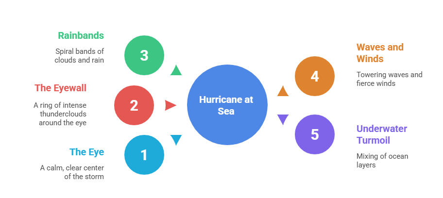
- The Eye (center) – A calm, circular “hole” in the clouds at the storm’s center. It’s often clear of clouds and surprisingly peaceful. NOAA notes it’s “the calmest part of the storm”, and NASA says air sinking in the eye creates a “calm, cloud-free area”. If you were there, you might even see blue sky overhead!
- The Eyewall – A tall ring of towering thunderclouds around the eye. This is the ** fiercest part** of the hurricane. NOAA warns the eyewall is “where the strongest winds lurk”. Here winds can howl at 100+ mph and rainfall is heaviest. The eyewall looks like a thick, circular wall of angry gray clouds and often rises higher than any other part of the storm.
- Rainbands – These are long, curved bands of clouds and rain spiraling outward from the eyewall. They look like enormous arms wrapping around the storm. NASA describes them as “spiral rain bands”. Each band can stretch for hundreds of miles and brings squalls, gusts, and heavy showers. Visually, rainbands often appear as fuzzy, spiral arms circling the eye when seen from above.
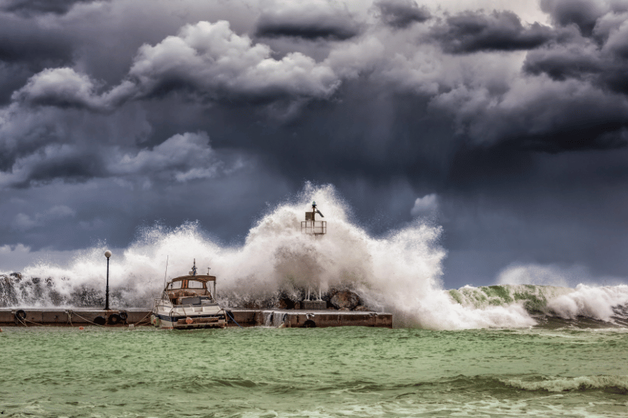
- Gigantic Waves and Winds – At the ocean surface, the hurricane churns the sea into chaos. You’d see a vast field of dark, towering waves. Scientists note that hurricanes create “massive waves – some reaching up to 60 feet in height”. Expert forecasts even warn of waves over 50–100 feet in extreme cases. The wind roars over the water so fiercely that whitecaps and foam blanket the surface. From a distance, the ocean under a hurricane looks like it’s boiling or towering with high, chaotic waves.
- Underwater Turmoil – Beneath the surface, the hurricane is mixing the ocean layers. Powerful winds drag warm surface water down and pull cold deep water up. Ocean scientists explain that a passing hurricane “drives warm water deeper into the ocean and in return brings cooler waters up to the surface”. This creates a swirl of water like a huge underwater blender. So underwater, the sea is not calm – it’s a stirred up mess of warm and cold currents.
The Eye: Calm Center of the Storm
At the very center of the hurricane is the eye – a remarkable calm spot. If you were in the eye, you’d find strangely clear skies and light winds, almost as if the storm took a brief coffee break around you. NOAA describes it as a clear, calm center surrounded by a wall of deadly winds. The eye usually spans 10–30 miles across. Around its rim is the eyewall – the hurricane’s “engine” – so even though the eye itself is peaceful, look closely and you’ll see the eyewall’s towering clouds and raging winds just outside the circle. In fact, the NOAA/University of Wisconsin researcher William Straka says the hurricane “rotates around a central core” marked by the eye wall and spiral rainbands – that core is exactly where you find the clear eye.
The Eyewall: The Storm’s Fury
Encircling the eye is the eyewall, the ring of the strongest thunderstorms. To an observer, the eyewall looks like a wall of dense clouds rising high into the sky. This is where the storm’s energy and violence are focused. As NOAA notes, the eyewall is “where the strongest winds lurk”. Here you’d feel the hurricane’s worst: hurricane-force gusts, driving rain, and waves battered by the wind. Pilots have even described the eye wall’s clouds as a “stadium” of thunderstorms around the clear eye. In satellite photos, the eyewall appears as a bright white circular band around the eye. In simple terms, if the eye is the calm eye of a needle, the eyewall is the thick, rough fabric around it – the very part of the storm doing all the work.
Spiral Rainbands: The Storm’s Arms
Beyond the eyewall, spiral rainbands extend outward like the storm’s arms. These look like curving ribbons of clouds spiraling out from the center. They can be dozens to hundreds of miles long. In the sky, each rainband brings heavy showers, gusts, and sometimes tornadoes. On satellite images, rainbands are the spiral streaks wrapping around the eye. NASA explains these as curved bands of clouds that trail away in spiral fashion. These spiraling arms are part of what gives the hurricane its classic pinwheel appearance. An expert (William Straka) describes this rotation as the storm’s engine: “the convection surrounding the circulation acts as the engine that sustains a hurricane” – the spiral rainbands are part of that convection system.
High Waves and Wild Winds at Sea
On the ocean surface, a hurricane is truly dramatic. The winds whip the water into giant waves and spray. Reports note that the seas can be incredibly wild – waves in the tens of feet are normal, and under an intense storm they can reach 50–60 feet high or more. From aboard a ship (if one could brave it), you would see walls of dark green water cresting with white foam, rolling in chaotic patterns. The winds themselves would be a howling roar. Essentially, the sea under a hurricane looks like one big, angry cauldron. Storm surge also bulges the ocean, pushing water onshore in a “dome” up to 30–40 feet above normal level, but out in the open ocean it just means even bigger waves.
Under the Surface: Ocean Mixing
While the sky and surface look wild, the hurricane also affects the ocean depths. Powerful winds churn the upper 90 meters (hundreds of feet) of water. Warm surface water is dragged downward, and cold deep water is pulled up. Woods Hole researchers explain that a passing hurricane “drives warm water deeper into the ocean and in return brings cooler waters up to the surface”. So if you could look underwater, you’d see the water column mixing – warmer, tropical surface water being mixed with colder, nutrient-rich deeper water. This can have big effects on marine life, but visually it means the once-stable layers of ocean are disrupted. In summary, under the waves, the ocean appears very disturbed, like a stirred-up soup of warm and cold waters.
What You’d Experience on a Ship
Imagine you’re on a boat approaching the storm. At first, the air might just pick up a bit, and the sky would rapidly cloud over. Soon you’d hear winds crescendo to hurricane force, gusting at maybe 100 mph or more. The ocean would become extremely rough – your ship would pitch and roll over monstrous swells. The air would be filled with driving rain. If you somehow stayed on course and reached the eye, everything would abruptly calm: winds would die down, rain would stop, and you might see a patch of blue sky – the eye’s floor of green water beneath a clear blue dome. This eerie calm has been described by sailors and is exactly what scientists expect (the eye is notably “cloud-free” and calm). But as soon as you exit the eye on the other side, the cyclone would pick up again from the opposite direction – winds roaring and waves crashing from the storm’s other side. In short, being at sea in a hurricane means experiencing total chaos, then sudden calm, then chaos again.
Key Takeaways
A hurricane at sea is unmistakable. From above it looks like a huge spinning disk of clouds with a clear center. At the ocean surface it looks (and feels) like the wildest sea imaginable: towering waves and howling winds everywhere. The center eye is odd in contrast: a calm blue ‘bullseye’ amid the storm. Underwater, the hurricane stirs the ocean deeply, mixing warm and cold layers. As NOAA imagery shows, powerful hurricanes often have a nearly circular eye surrounded by dense clouds. In short, you’d see a giant spiral cloud formation, feel hurricane-force weather, and witness a churning sea – a breathtaking (and terrifying) sight that underscores why scientists call hurricanes some of the planet’s most violent storms